ShefField bird count results
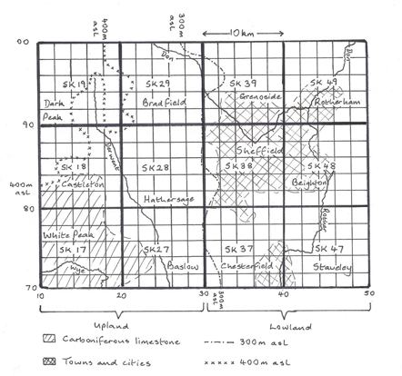
These maps refer to the 300 tetrads in the Sheffield area (as covered by the Sheffield Bird Study Group). Note that the left half of the map is mostly upland (Peak District) and the right half is mostly lowland.
They are based mostly on a tetrad survey carried out by SBSG members during 1988-90. Members were asked to make 1-hour visits in the breeding season and COUNT each bird they saw or heard. At the same time, the BTO was conducting the national 'New Atlas' survey which included asking observers to make one-hour counts. The BTO kindly made available the details of those counts in the tetrads in this area.
The numbers on the maps show how many of that species were found in a one hour visit during 1988-90. Many tetrads received multiple visits in which case the maps show how many were counted in the one hour in which the most species were found; species found in other visits outside of that one hour period are shown with a tick. Further 'ticks' were added based on records supplied to the SBSG during those years and published in the Sheffield Bird Reports (1988-90). Some ticks may cross tetrad boundaries if it wasn't clear exactly which tetrad the sighting refers to.
Other information was added to the maps as follows:
R - species found in this tetrad in the breeding season during a survey of the birds of the Rother Valley in 1990
M - species found in this tetrad during a survey of South Pennine moorlands in 1990, funded by the Nature Conservancy Council and published in a report by Brown and Shepherd (1991). This survey only reported moorland birds
L - species found in this tetrad during a survey of the breeding birds of the Limestone Dales by Dave Gosney. Note that this survey was carried out in 1993, not 1988-90 but helps to fill some of the gaps of species missed during the original tetrad survey.
NC - species present but too difficult to count eg flocks of corvids
Coverage
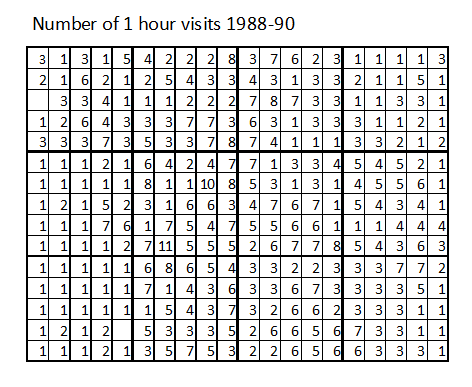
When studying the species maps you might wonder whether the absence of a species (ie not even a tick) is simply due to the limited time spent in each tetrad. The following maps show how many hours of data were available for each tetrad.
This map shows the number of hours spent in each tetrad during the SBSG and BTO surveys. Not every visit yielded count data; sometimes just a species list was provided.
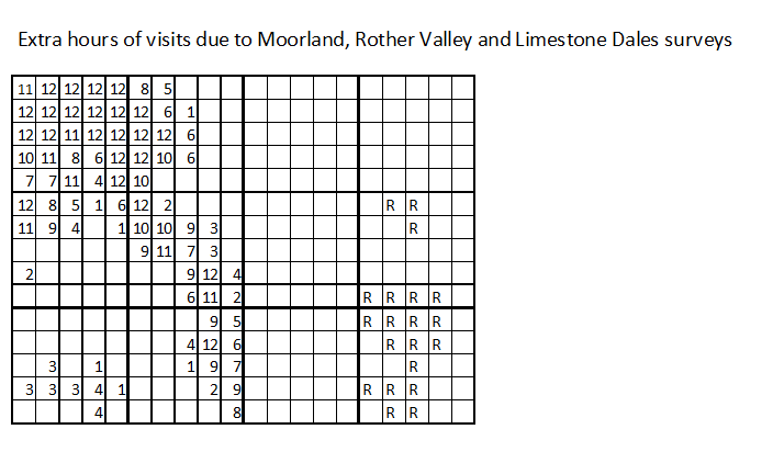
This map shows the number of additional hours spent in each tetrad during the Moorland Birds and Limestone Dales surveys and the tetrads represented during the Rother Valley Survey (in which the number of hours spent is not known)
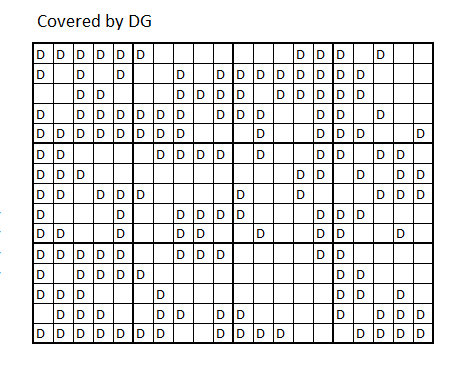
This map shows the number of tetrads in which at least one count was made by me. This has no scientific value; I'm just proud of it and wanted to show off.
By the way, the numbers by the side of each species map have been kept in case they are useful. The top number refers to the number of tetrads in which the species was counted in the chosen hour. The next number is the additional number of tetrads in which the species was found outside of that hour (ie the number of ticks on the map). These numbers kept changing as more information came in; I can’t guarantee they represent exactly the final totals as shown on the maps.
Interpreting the maps